Land
The EPA plays a leading role in a range of land-related mapping and assessment activities in Ireland, particularly in the production and co-ordination of national land evidence data.
Land Evidence Data
Land evidence data refers to information that records a range of human activity (land use) and/or bio-physical characteristics of the land surface at a given location.
Land evidence data can be recorded and stored in tabular format but more commonly is in the form of geo-spatial (GIS) maps and datasets e.g. thematic raster images; point, polygon or similar vector geometries. The information in these datasets is usually categorised based on a pre-defined thematic classification system.
Land evidence data can be obtained from field-based sampling and data collection; in-situ sensors and cameras; or more frequently through remote sensing of aerial photography and satellite imagery (Earth Observation).
The granularity of detail provided by land evidence data depends on the geometric resolution (minimum mapping unit) of the dataset and the thematic classification system used.
The most common forms of land evidence data are landcover, landuse and habitat maps. Other examples of land evidence data includes statistical records, agricultural and forestry data, soil samples, citizen science records and research data.
Landcover
Landcover describes what is physically present on the Earth’s surface. This includes biotic (vegetated) surfaces such as grasslands, forestry and peatland; and abiotic (unvegetated) surfaces such as water, exposed rock and artificial surfaces.
In Ireland there is continuous time series of landcover data since 1990, provided by the pan-European Landcover dataset. The EPA has produced CORINE for Ireland since 2000 - see more information here.
In 2023, Tailte Eireann, in partnership with the EPA, published the National Land cover map of Ireland 2018 (NLC 2018). This provided the first high-resolution landcover dataset for Ireland. See more information here
Landuse
Land use refers to human socio-economic activity that takes place on the land. It is a crucial element in how we interact with, benefit from and harm the environment. When managed in a sustainable way, landuse activity can result in safe-guarded biodiversity and natural spaces, greenhouse gas sequestration and abatement, clean drinking water and the provision of healthy food. In contrast, unsustainable landuse activity can lead to polluted drinking and bathing waters, missing our national carbon reduction target and degraded habitats.
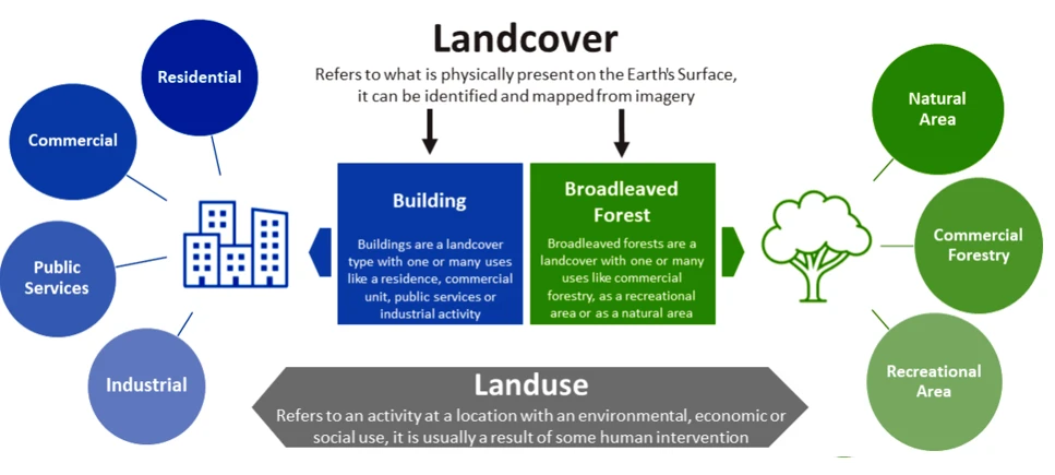
Fig 1. Image illustrating the differences between Landcover and Landuse
For more information on Land and Land Evidence data see the chapter 5 of the EPA’s State of the Environment Report 2024: State of the Environment Report – Chapter 5: Land