About
The Integrated Carbon Observation System
The Integrated Carbon Observation System (ICOS) is a European Research Infrastructure Consortium (ERIC) that is designed to provide high quality, long-term Greenhouse Gas (GHG) observational data for the atmosphere, oceans and a range of land-use types. The data are essential to our understanding of the key drivers of climate change, and the effectiveness of policy to address GHG emissions and removals. ICOS data support climate change research and helps inform and shape climate and environmental policy. ICOS is a key European contribution to the Global Climate Observation System under the UN Framework Convention on Climate Change and the Paris Agreement.
ICOS is comprised of a network of observation stations and platforms, thematic centres for the Atmosphere, Ocean and Ecosystem domains, and the ICOS Carbon Portal, where data is freely available to users (Figure 1). The ICOS Headquarters of its central secretariat are hosted in Finland.
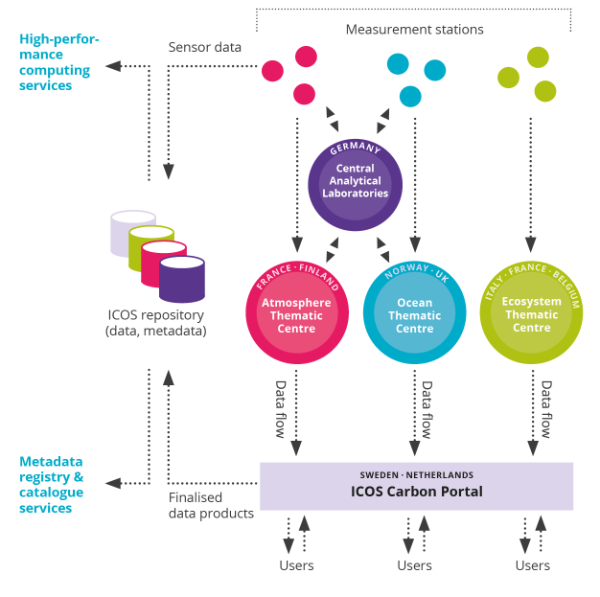 Figure 1. Data Flow
ICOS Aims
Since the industrial revolution, the ongoing increased emissions of greenhouse gases, principally carbon dioxide, methane and nitrous oxide, is trapping more energy in the Earth’s atmosphere, oceans and terrestrial systems, resulting in significant changes and impacts. As a consequence, the global average temperature has increased by over 1°C since the pre-industrial era. This increasing energy in the Earth's system is sometimes termed global warming or global climate change.
The main purposes of ICOS include:
- To provide long-term high-quality greenhouse gas observational data that support research on key global cycles such as the carbon and nitrogen cycles and the human influences on these.
- To support analysis of greenhouse emissions and removals at a range of scales to validate and improve earth systems models and data used in national greenhouse gas inventory development.
- To assess, inform and develop policies, measures and management strategies to reduce or eliminate greenhouse gas emissions or enhance removals.
ICOS data are particularly useful for analysis of natural or managed systems such as forests, grazing lands, peatland and oceans. These are important carbon sinks but are also vulnerable to climate change. ICOS data helps understand the vitality of these sinks and how they are responding to a changing climate.
ICOS Stations
Stations are located in three domains: atmosphere, ecosystem and ocean. ICOS classifies stations into three types:
- Class 1: Measures a full set of variables
- Class 2: Measures a smaller, standardised set
- For Ecosystem stations only, Associated stations measure a basic set of variables
All stations follow strict procedures to ensure data quality. Some also include extra instruments for specific research.