Coastal Flooding
Overview
- Currently, coastal flooding poses a serious threat for Ireland. This is due to the fact that Ireland's cities and key infrastructure are located at or near the coast.
- Sea levels will continue to rise for the coming century while the magnitude and intensity of coastal storms are expected to increase.
- These changes will mean that areas currently at risk of flooding will be at greater risk while areas previously not considered at risk may be at increased risk due climate change.
- Approaches which serve to preserve or protect the shoreline may not be optimal in the long-term and a more effective approach may be to manage change in the coastal zone so as it is allowed to adjust to expected changes.
- This requires a high level of understanding of the coastal system supported by effective monitoring of vulnerable locations to identify where and when remedial action may be necessary.
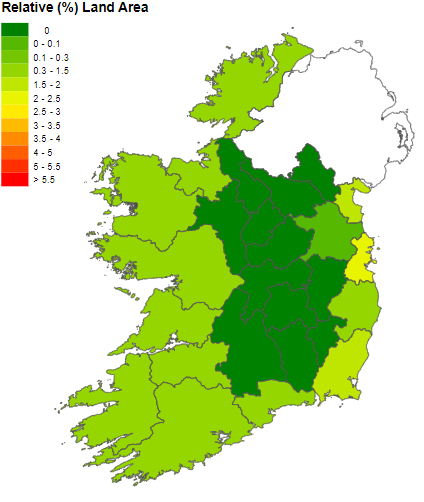
Map showing percentage land area per county at risk of inundation at a sea level rise of 1m. This projection does not account for isostatic rebound or the existence of coastal defences [Flood et al., 2011].
Current exposure
Coastal flooding poses a serious threat for Ireland and this is particularly the case as most of Ireland's population and infrastructure are concentrated on the coast and in the coastal cities of Dublin, Cork, Limerick and Galway. Current exposure to coastal flood risk is determined by a number of factors including: topography, storm surge and sea level rise.
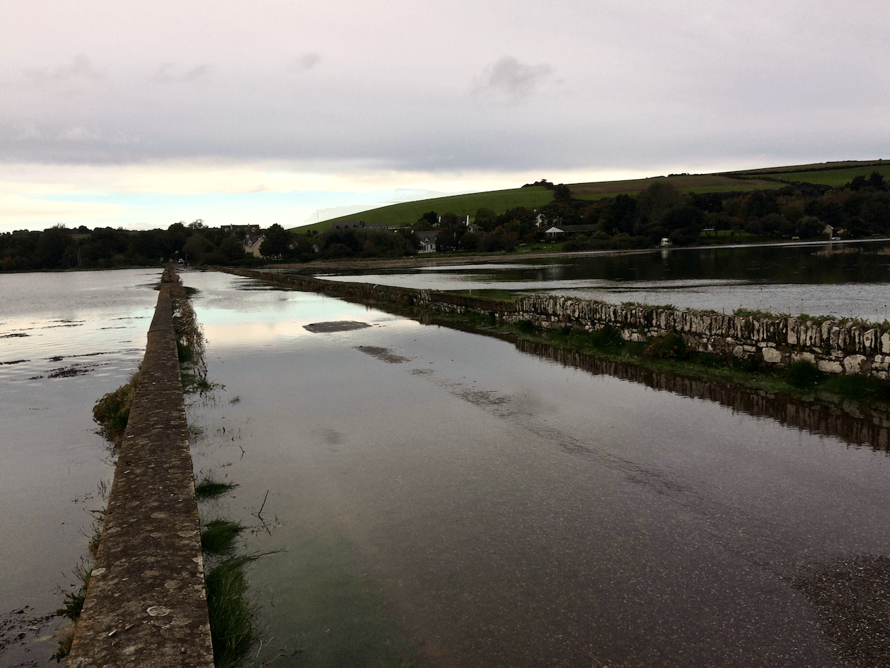
Tidal flooding at Ballinclashet Crossroads (Oysterhaven, Cork) in the south of Ireland (Photo credit: Tim O'Higgins).
Topographic Variation
There is strong topographical variation between the Atlantic and Irish sea coasts. The Atlantic coastline is dominated by high relief and rock cliffs interspersed with bays while the Irish sea coast is mainly low-lying. Currently, coastal flood risk is highest in low-lying areas along the east coast from Dundalk to Dublin and along the Wicklow to Wexford coast while on the south coast, coastal flood risk is also evident in the low lying areas of Waterford, Dungarvan, Youghal and Cork City. On the west coast Galway city and the Shannon estuary are also at risk.
Storm Surge
Tide levels are rarely exactly as predicted. The difference between a higher than expected sea level and the predicted tide is referred to as a surge. Surges generally occur when high onshore winds pile the water up on the coast or when an area of low barometric pressure causes the water level to rise.
The incidence of coastal flooding is heavily associated with the occurrence of storm surges coinciding with high spring tides, which serves to elevate sea level above those predicted. For example, in February 2002, a low pressure system in the southern Irish Sea coincided with a spring tide, leading to an extreme water level of 2.9m above mean sea level and resulted in widespread flooding in Dublin and marked coastal erosion on the south and east coasts.
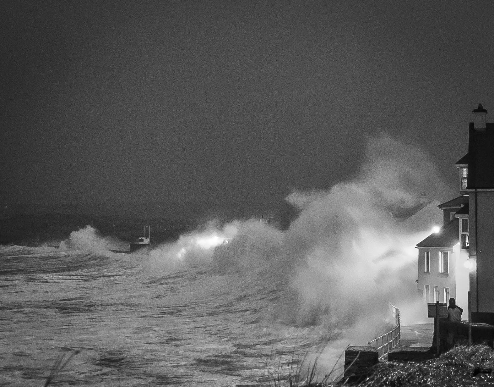
Overtopping at Lahinch Strand during Storm Hercules (January 2014) - (Photo credit: Aldert Otter).
Sea Level Rise
For Ireland, sea levels are rising and these increases have been linked to three primary factors:
- Thermal Expansion: Increasing global temperature has meant that the oceans are now absorbing heat from the atmosphere resulting in the thermal expansion of the oceans (warmer water is less dense than colder water) and increasing sea levels.
- Melting of glaciers and the polar ice caps: As the temperature of the atmosphere and oceans increase, glaciers and ice sheets melt resulting in the release of meltwater into the oceans, thus contributing to sea level rise.
- Isostatic rebound: The land surface of Ireland is still responding to the melting of the ice sheets during the last Ice-Age. Ireland is slowly tilting, with the south of Ireland slowly sinking while the north of Ireland is rising.
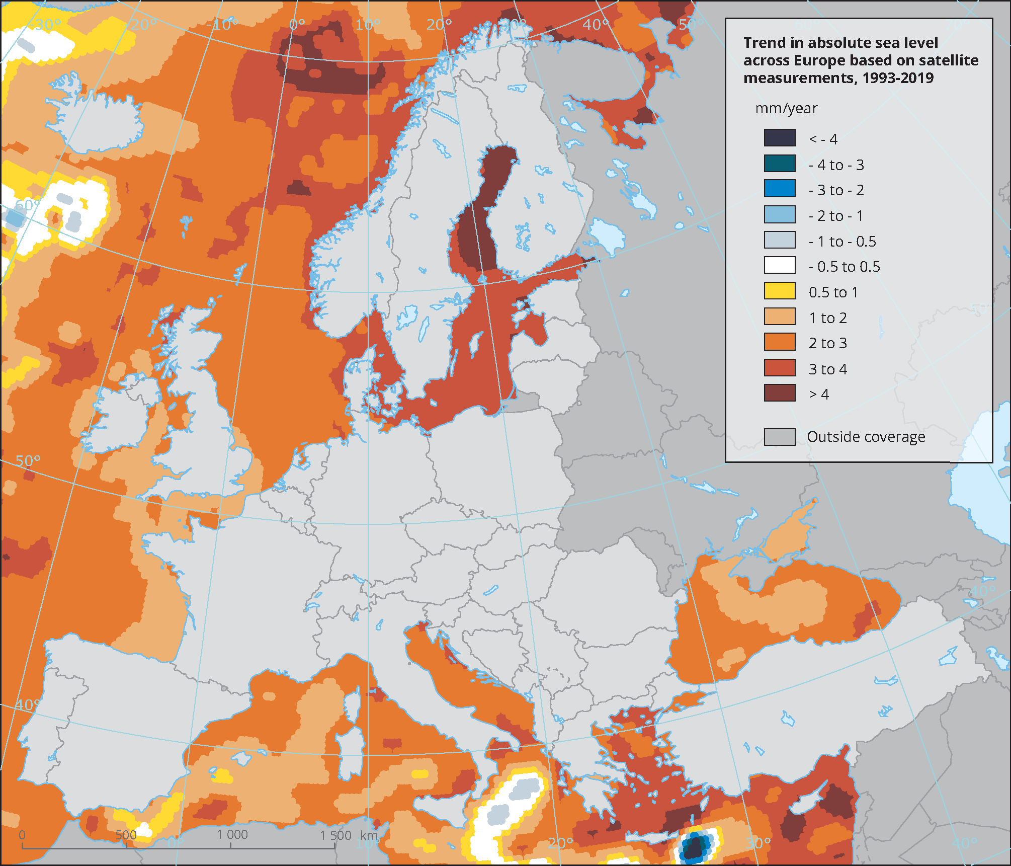
Spatial distribution of trends in mean sea level in European Seas (1993-2019) [EEA, 2016].
Click here for more information on observed changes in sea level from Ireland's Climate Status Report.
Future exposure
For Ireland, projected changes in sea level in combination with expected increase in storm activity will result in increased risk of coastal flooding. This increased risk extends to not only those areas already at risk of coastal flooding but also to new areas that are currently not considered at risk.
Projected changes in sea level
According to the IPCC, global sea level is expected to increase by 0.42m (0.28-0.55m; SSP1-1.9) for the very low emissions scenario and 0.82m (0.63-1.01m; SSP5-8.5) for the very high emissions scenario by the end of the century. However, due to a limited understanding of some of the important effects which are driving sea level rise, e.g. melting of the polar ice caps, a best estimate of future upper bound for sea level rise cannot be provided with confidence and estimates of up to 4m and 6m above current levels have been suggested.
On the basis of a global sea level rise projections in combination with isostatic rebound, projected rates of sea level rise vary substantially around the Irish coast:
- Areas of the extreme southwest, from the Dingle Peninsula to Cape Clear, are likely to experience the largest increases in sea level at a rate of 3.3-4.8 mm per year;
- Areas of the north east coast are likely to experience sea level rise at a rate of 2.2-3.7 mm per year.
As a result, it can be expected that areas of the south will likely feel the effects of sea level rise first, particularly low-lying coastal locations situated on soft or easily eroded materials and coastal floodplains. In addition, projected changes in sea levels are expected to enlarge the horizontal and vertical extent of estuaries. This will result in the penetration of tides further upstream and would impede the flow of rivers and result in estuarine flooding.
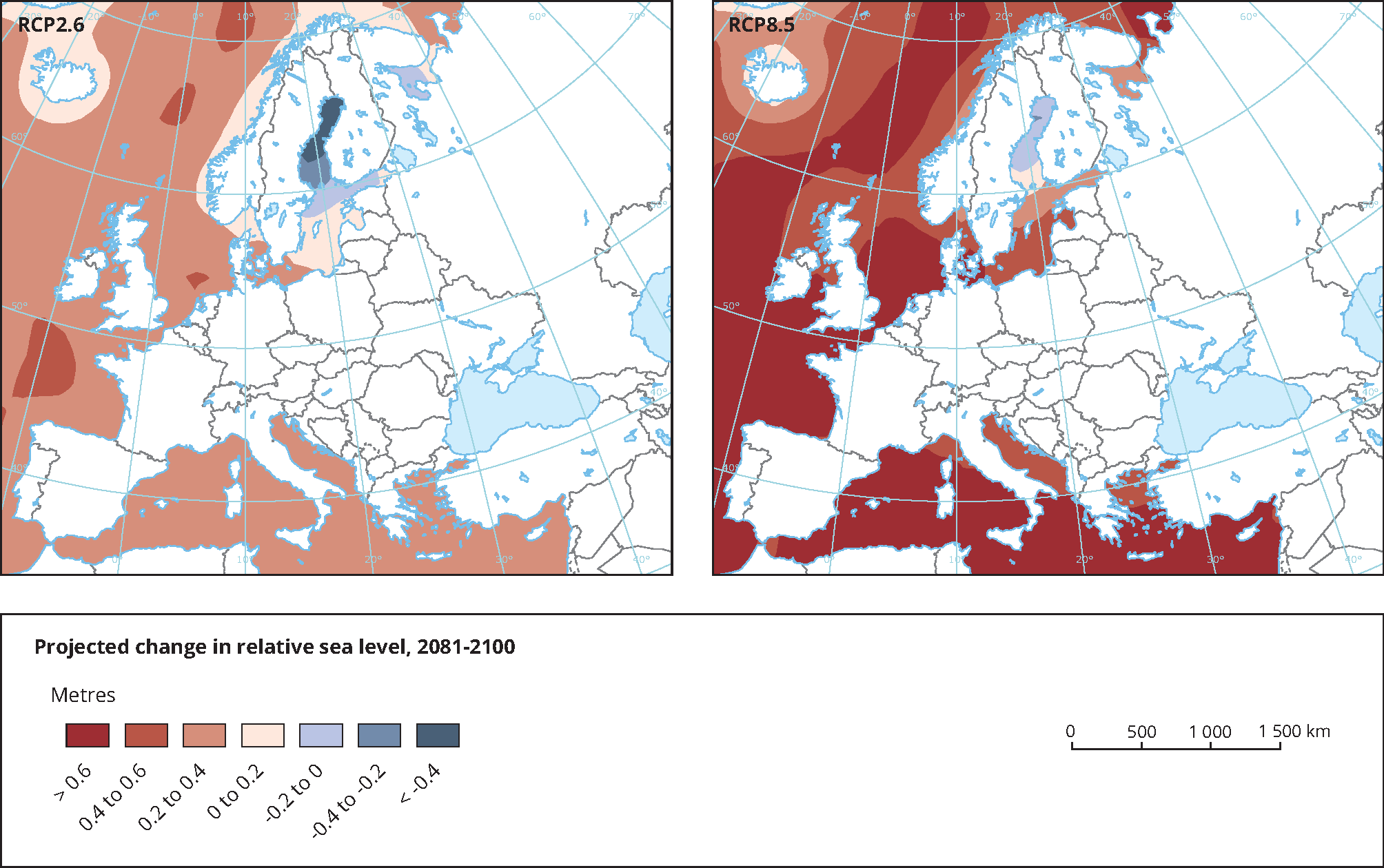
The map shows the projected change in relative sea level in 2081-2100 compared to 1986-2005. The left map shows projections for the low emissions scenario (RCP2.6) while the right map shows projections for the high emission scenario (RCP8.6) based on an ensemble of IPCC SROCC Report. Projections consider land movement due to glacial isostatic adjustment but not land subsidence due to human activities [EEA, 2019].
Projected changes in storm surge activity
Due to Ireland's location in the west of Europe, exposure to Atlantic storms is of concern and this is particularly the case in the context of rising sea levels which will enhance the impacts of storm surges.
According to the IPCC, an increase in the number of intense cyclones and associated strong winds, particularly over the North Atlantic, is likely. These changes will have a direct impact on storm surges.
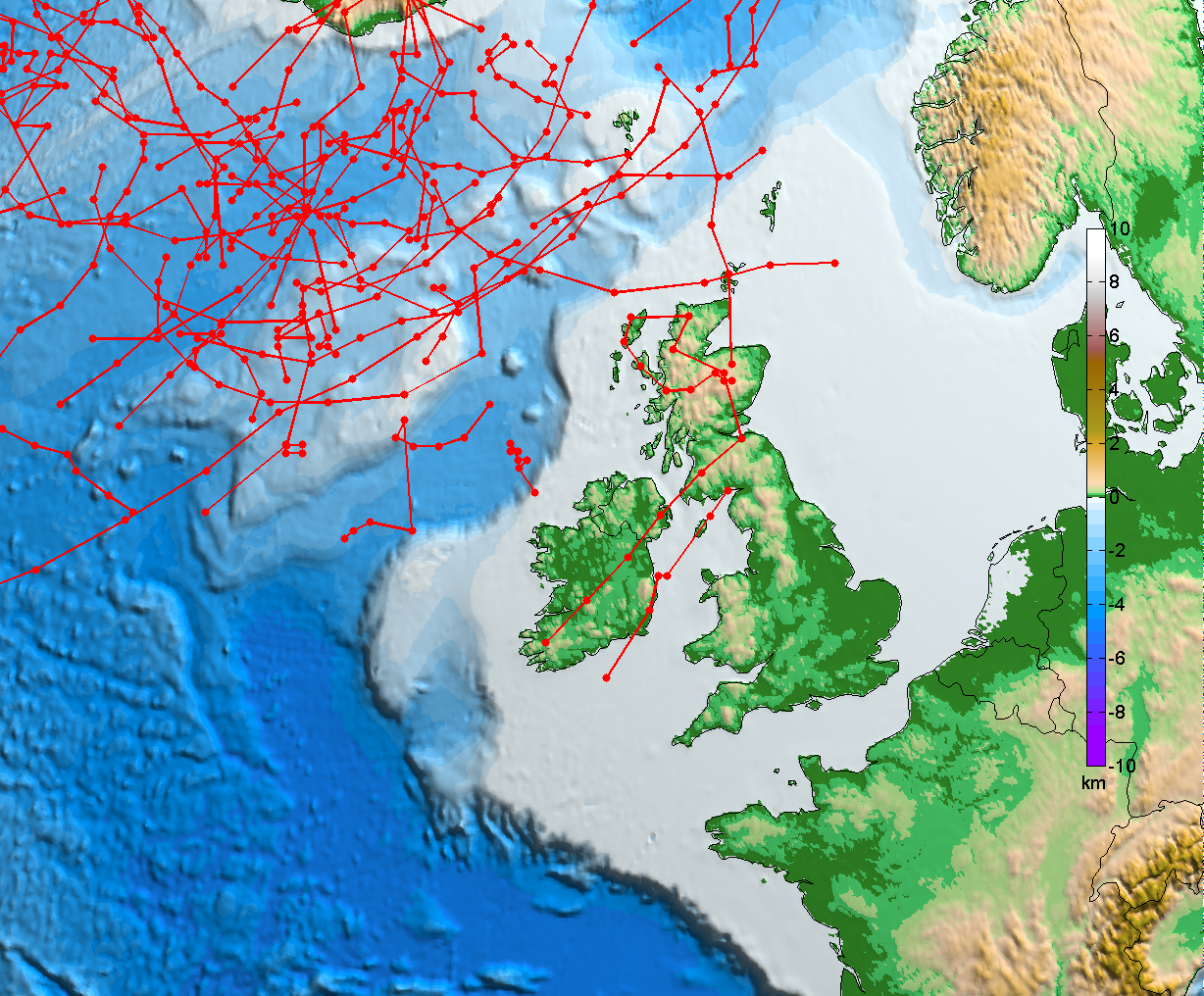
Tracks of storms with a core of less than 940 hPa and with a lifetime of at least 12 hours (1981-2000) [IPCC, 2007].
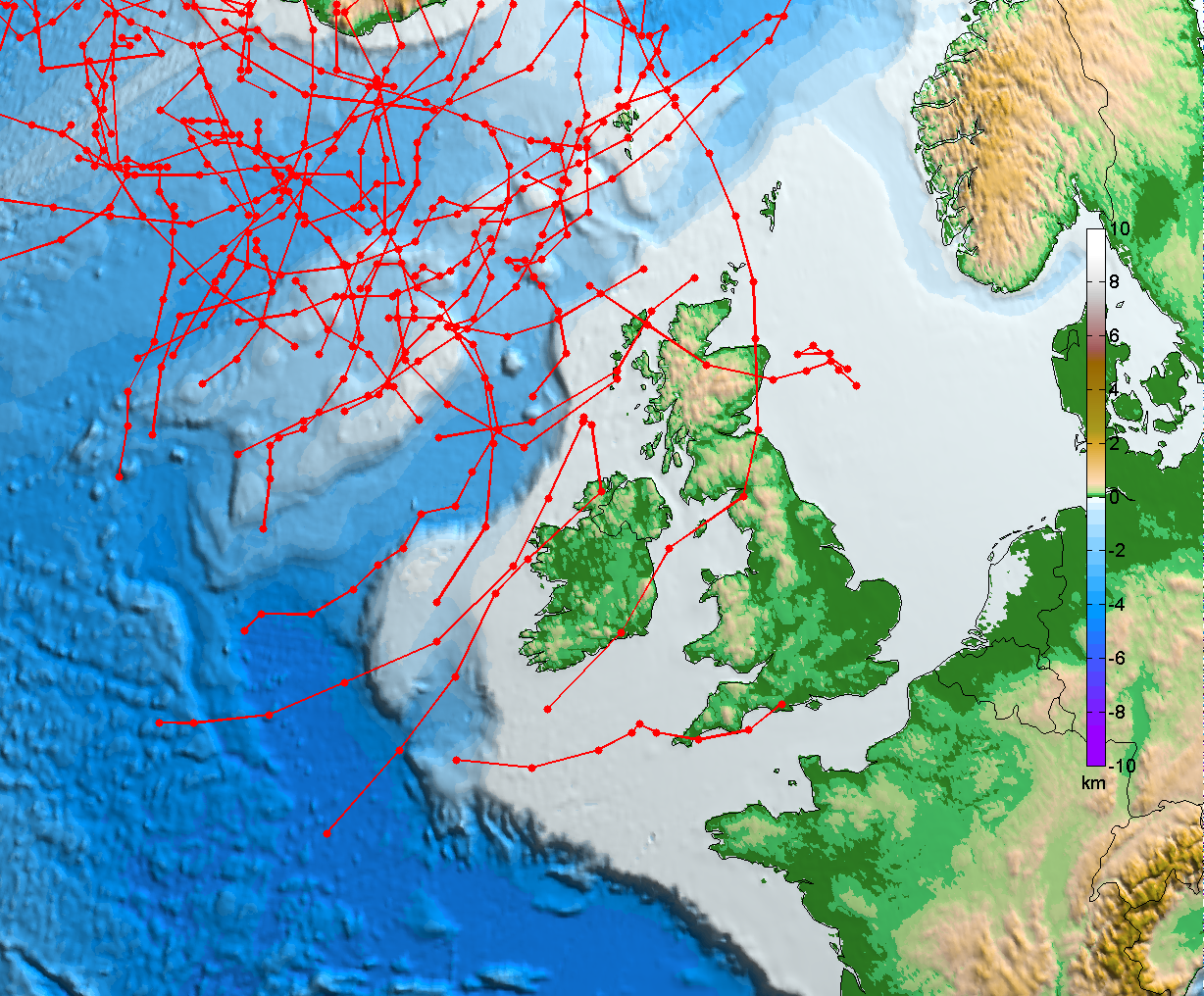
For the high emissions scenario (RCP 8.5): projected tracks of storms with a core of less than 940 hPa and with a lifetime of at least 12 hours (2041-2060) [IPCC, 2007].
Projected inundation
Not taking into account the existence of coastal defences or isostatic-rebound, under a projected sea level rise of 0.5 m, it is estimated that 200 km2 of land area in the Republic of Ireland is at risk of inundation and this is particularly the case for low lying areas of the Irish coast.
The counties most at risk under a sea level rise of 0.5m are Wexford, Kerry and Cork. However, in terms of relative land vulnerabilities, Dublin, Louth and Wexford are at highest risk. Under a projected sea level rise of 6m, it is estimated that close to 1200 km2 of land area would be at risk.
Of more immediate concern for Ireland is the impacts of storm surge superimposed on relative sea level rise. On the basis of a sea level rise of 0.48 m coupled with an extreme surge of 2.6 m, representing a 1-in-100 year event on the east coast and a 1-in-12 year event on the west coast, it is estimated that approximately 600 km2 of land would be at risk of inundation. While the current return period for such an event is lower on the east than the west coast, an increase in frequency for such events is projected for both coasts and indicates that a substantial amount of land could be inundated on a more regular basis. For example, the current 1-in-100 year event is likely to become a 1-in-10 year event or less.
Current and projected coastal flood extents: For information on current and projected future flood extents for Ireland, go to the OPW FloodInfo website.
Implication for management
Due to the uncertainties surrounding projections of sea level rise and storm surges, a new approach is required for coastal protection. Traditional hard engineering structures, such as sea walls may still be needed where settlements or infrastructure are threatened by the sea. However, in areas where land is less valuable, the policy should be more accommodating and adjustable.
Approaches which serve to preserve or protect the shoreline may not be optimal in the long-term and a more effective approach may be to manage change in the coastal zone so as it is allowed to adjust to environmental changes. This requires a high level of understanding of the coastal system supported by effective monitoring of vulnerable locations to identify where and when remedial action may be necessary.
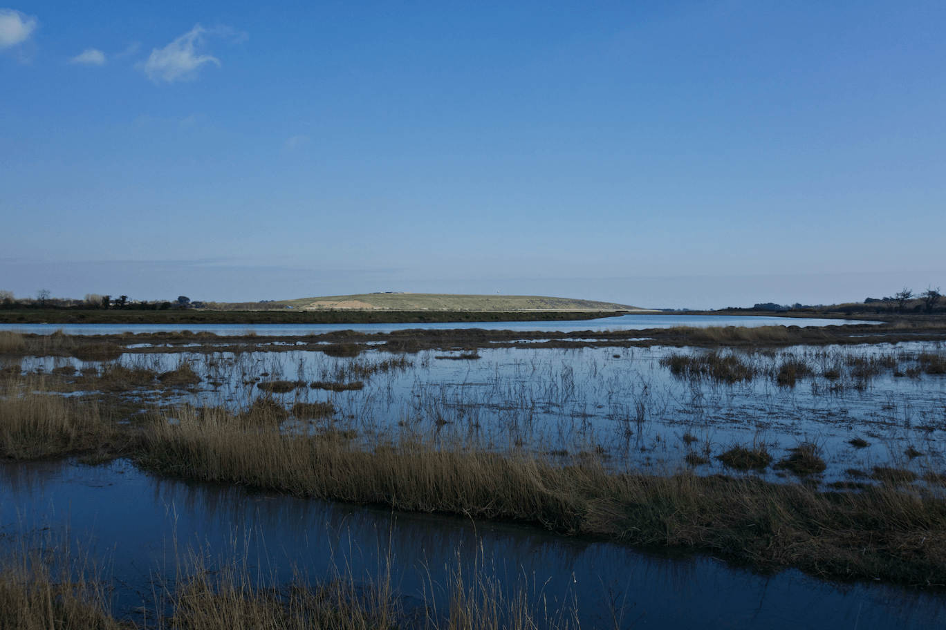
Saltmarsh areas of the Rogerstown Estuary are being employed for both biodiversity protection and as natural flood coastal defence [photo credit: Barry O'Dwyer].
Management for the short term
In the short-term, a number of measures might be taken:
- Current areas at risk of flooding should be immediately identified and development in these areas should be stopped;
- Adopting a precautionary approach, areas at risk of future flooding should be identified and development in these areas restricted. This might be achieved through the designation of a set back area from the shoreline on which development would be restrained;
- Coastal inundation hot spots should be identified, i.e. areas where high economic losses might be realised under projected changes in sea level;
- Natural coastal defences should be identified, e.g. salt marshes, and development restricted in these areas.
Management in the medium to long term
In the medium to long-term:
- Due to uncertainties associated with projected sea level rise, planned coastal defences should be flexible and assessed against the full range of climate scenarios;
- Local actions to reduce vulnerability should be assessed against the larger spatial and temporal context of coastal dynamics, e.g. sediment budget, so as not to initiate or erosion further along the shore.
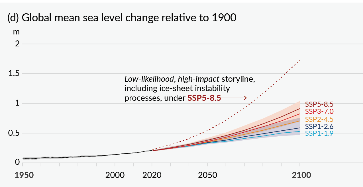
Projections of global mean sea level rise over the 21st Century [IPCC, 2021].